Antarctic glacier melting faster than previously estimated
Newly digitized vintage film has doubled how far back scientists can peer into the history of underground ice in Antarctica
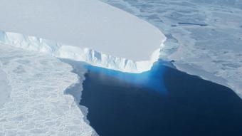
Newly digitized vintage film has doubled how far back scientists can peer into the history of underground ice in Antarctica, and revealed that an ice shelf on Thwaites Glacier in West Antarctica is being thawed by a warming ocean more quickly than previously thought.
This finding contributes to predictions for sea-level rise that would impact coastal communities around the world.
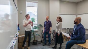
The researchers – including a Colorado School of Mines geophysics professor – made their findings by comparing ice-penetrating radar records of Thwaites Glacier with modern data. The research appeared in the Proceedings of the National Academy of Sciences on Sept. 2.
“Being a part of such a unique project to give new life to old data has been a highlight of my career so far,” said Matthew Siegfried, assistant professor of geophysics. “Ice sheets change on time scales ranging from minutes to millennia, so being able to recreate an older configuration of the Antarctic ice sheet and double the length of our detailed history of change represents a significant step toward being able to separate true changes from noise in the climate system.”
Led by Stanford University’s Dustin Schroeder, assistant professor of geophysics in the School of Earth, Energy & Environmental Sciences, researchers digitized about 250,000 flight miles of Antarctic radar data originally captured on 35 mm optical film between 1971 and 1979 as part of a collaboration between Stanford and the Scott Polar Research Institute (SPRI) at Cambridge University in the U.K.
The data has been released to an online public archive through Stanford Libraries, enabling other scientists to compare it with modern radar data in order to understand long-term changes in ice thickness, features within glaciers, and baseline conditions over 40 years.
For Larry Irons, software and systems support engineer for the Mines Geophysics Department, seeing the revived recordings is especially meaningful – he was a member of the SPRI data collection crew for two field seasons from 1977 to 1979 as part of his master’s degree work.
“During those two field seasons, I spent about 25,000 miles in the air recording radio echo sounding data across all parts of Antarctica. I saw the radar data freshly recorded on a printer that we had in the Navy C-130 Hercules aircraft. I also changed film canisters while in flight,” Irons said. “It is very satisfying to know that my effort on the team is still useful today. It is incredible that analog film data recorded 40 years ago can be digitized and enhanced with modern digital techniques.”
Sea-level predictions
The information provided by the historic records will help efforts such as the Intergovernmental Panel on Climate Change in its goal of projecting climate and sea-level rise for the next 100 years. By being able to look back 40 to 50 years at subsurface conditions rather than just the 10 to 20 years provided by modern data, scientists can better understand what has happened in the past and make more accurate projections about the future, Schroeder said.
“You can really see the geometry over this long period of time, how these ocean currents have melted the ice shelf – not just in general, but exactly where and how,” said Schroeder. “When we model ice sheet behavior and sea-level projections into the future, we need to understand the processes at the base of the ice sheet that made the changes we’re seeing.”
The film was originally recorded in an exploratory survey using ice-penetrating radar, a technique still used today to capture information from the surface through the bottom of the ice sheet. The radar shows mountains, volcanoes and lakes beneath the surface of Antarctica, as well as layers inside the ice sheet that reveal the history of climate and flow.
Newly uncovered features
The researchers identified several features beneath the ice sheet that had previously only been observed in modern data, including ash layers captured inside the ice from past volcanic eruptions and channels where water flowing out from beneath the ice sheet is eroding the bottom of floating ice shelves. The longer time series paints a complex picture of change: while one of these sub-ice channels has remained stable over the past 40 years, the Thwaites Glacier ice shelf has thinned between 10 and 33 percent between 1978 and 2009.
The scientists hope their findings demonstrate the value of comparing this historical information to modern data to analyze different aspects of Antarctica at a finer scale. In addition to the radar data, the Stanford Digital Repository includes photographs of the notebooks from the flight operators, an international consortium of American, British and Danish geoscientists.
Fellow contributors at Stanford include postdoctoral researcher Winnie Chu; graduate students Emma MacKie and John Emmons; Summer Undergraduate Research in Geoscience and Engineering (SURGE) participant Katherine Vega, now with the University of Colorado; and Assistant Professor of Computer Science Keith Winstein. Other co-authors are affiliated with the University of Cambridge, Imperial College London and the University of Edinburgh. The research was supported by NASA, the National Science Foundation and the George Thompson Fellowship at Stanford University.

About Mines
Colorado School of Mines is a public R1 research university focused on applied science and engineering, producing the talent, knowledge and innovations to serve industry and benefit society – all to create a more prosperous future.