NASA space lasers map meltwater lakes in Antarctica with striking precision
Geophysics Assistant Professor Matthew Siegfried was lead investigator on new study, published today in Geophysical Research Letters
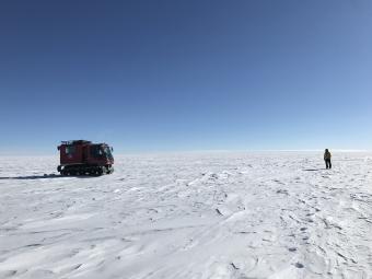
NASA researchers on the surface of the Antarctic Ice Sheet as part of the 88-South Traverse in 2019. The 470-mile expedition in one of the most barren landscapes on Earth provides the best means of assessment of the accuracy of data collected from space by the Ice Cloud and land Elevation Satellite-2 (ICESat-2). (Photo credit: NASA Goddard Space Flight Center/Dr. Kelly Brunt)
By Roberto Molar Candanosa, NASA Science Writer
From above, the Antarctic Ice Sheet might look like a calm, perpetual ice blanket that has covered Antarctica for millions of years. But the ice sheet can be thousands of meters deep at its thickest, and it hides hundreds of meltwater lakes where its base meets the continent’s bedrock. Deep below the surface, some of these lakes fill and drain continuously through a system of waterways that eventually drain into the ocean.
Now, with the most advanced Earth-observing laser instrument NASA has ever flown in space, scientists have improved their maps of these hidden lake systems under the West Antarctic ice sheet—and discovered two more of these active subglacial lakes.
The new study provides critical insight for spotting new subglacial lakes from space, as well as for assessing how this hidden plumbing system influences the speed at which ice slips into the Southern Ocean, adding freshwater that may alter its circulation and ecosystems.
NASA’s Ice, Cloud and land Elevation Satellite 2, or ICESat-2, allowed scientists to precisely map the subglacial lakes. The satellite measures the height of the ice surface, which, despite its enormous thickness, rises or falls as lakes fill or empty under the ice sheet.
The study, published July 7 in Geophysical Research Letters, integrates height data from ICESat-2’s predecessor, the original ICESat mission, as well as the European Space Agency’s satellite dedicated to monitoring polar ice thickness, CryoSat-2.
Hydrology systems under the Antarctic ice sheet have been a mystery for decades. That began to change in 2007, when Helen Amanda Fricker, a glaciologist at Scripps Institution of Oceanography at the University of California San Diego, made a breakthrough that helped update classical understanding of subglacial lakes in Antarctica.
Using data from the original ICESat in 2007, Fricker found for the first time that under Antarctica’s fast flowing ice streams, an entire network of lakes connect with one another, filling and draining actively over time. Before, these lakes were thought to hold meltwater statically, without filling and draining.
“The discovery of these interconnected systems of lakes at the ice-bed interface that are moving water around, with all these impacts on glaciology, microbiology, and oceanography—that was a big discovery from the ICESat mission,” said Matthew Siegfried, assistant professor of geophysics at Colorado School of Mines and lead investigator in the new study. “ICESat-2 is like putting on your glasses after using ICESat, the data are such high precision that we can really start to map out the lake boundaries on the surface.”
Scientists have hypothesized subglacial water exchange in Antarctica results from a combination of factors, including fluctuations in the pressure exerted by the massive weight of the ice above, the friction between the bed of the ice sheet and the rocks beneath, and heat coming up from the Earth below that is insulated by the thickness of the ice. That’s a stark contrast from the Greenland ice sheet, where lakes at the bed of the ice fill with meltwater that has drained through cracks and holes on the surface.
To study the regions where subglacial lakes fill and drain more frequently with satellite data, Siegfried worked with Fricker, who played a key role in designing the way the ICESat-2 mission observes polar ice from space.
Siegfried and Fricker’s new research shows that a group of lakes including the Conway and Mercer lakes under the Mercer and Whillans ice streams in West Antarctica are experiencing a draining period for the third time since the original ICESat mission began measuring elevation changes on the ice sheet’s surface in 2003. The two newly found lakes also sit in this region.
In addition to providing vital data, the study also revealed that the outlines or boundaries of the lakes can change gradually as water enters and leaves the reservoirs.
“We're really mapping out any height anomalies that exist at this point,” Siegfried said. “If there are lakes filling and draining, we will detect them with ICESat-2.”
‘Helping Us Observe’ Under the Ice Sheet
Precise measurements of basal meltwater are crucial if scientists want to gain a better understanding of Antarctica’s subglacial plumbing system, and how all that freshwater might alter the speed of the ice sheet above or the circulation of the ocean into which it ultimately flows.
An enormous dome-shaped layer of ice covering most of the continent, the Antarctic ice sheet flows slowly outwards from the central region of the continent like super thick honey. But as the ice approaches the coast, its speed changes drastically, turning into river-like ice streams that funnel ice rapidly toward the ocean with speeds up to several meters per day. How fast or slow the ice moves depends partly on the way meltwater lubricates the ice sheet as it slides on the underlying bedrock.
As the ice sheet moves, it suffers cracks, crevasses, and other imperfections. When lakes under the ice gain or lose water, they also deform the frozen surface above. Big or small, ICESat-2 maps these elevation changes with a precision down to just a few inches using a laser altimeter system that can measure Earth’s surface with unprecedented detail.
Tracking those complex processes with long-term satellite missions will provide crucial insights into the fate of the ice sheet. An important part of what glaciologists have discovered about ice sheets in the last 20 years comes from observations of how polar ice is changing in response to warming in the atmosphere and ocean, but hidden processes such as the way lake systems transport water under the ice will also be key in future studies of the Antarctic Ice Sheet, Fricker said.
“These are processes that are going on under Antarctica that we wouldn't have a clue about if we didn't have satellite data,” Fricker said, emphasizing how her 2007 discovery enabled glaciologists to confirm Antarctica’s hidden plumbing system transports water much more rapidly than previously thought. “We've been struggling with getting good predictions about the future of Antarctica, and instruments like ICESat-2 are helping us observe at the process scale.”
‘A Water System That Is Connected to the Whole Earth System’
How freshwater from the ice sheet might impact the circulation of the Southern Ocean and its marine ecosystems is one of Antarctica’s best kept secrets. Because the continent’s subglacial hydrology plays a key role in moving that water, Siegfried also emphasized the ice sheet’s connection to the rest of the planet.
“It's not just the ice sheet we're talking about,” Siegfried said. “We're really talking about a water system that is connected to the whole Earth system.”
Editor's Note: This story originally appeared on the NASA website. It is shared here with permission from the author. To read the full article, go to https://www.nasa.gov/feature/goddard/2021/nasa-space-lasers-map-meltwater-lakes-in-antarctica-with-striking-precision.

About Mines
Colorado School of Mines is a public R1 research university focused on applied science and engineering, producing the talent, knowledge and innovations to serve industry and benefit society – all to create a more prosperous future.